


Thông tin quy hoạch Quận 12
Description of Thông tin quy hoạch Quận 12
The main function of the application:
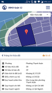
- Online maps:
+ View Map plan with 3 types of background: the parcel of land, the map background and the background image is not.
+ View information by clicking directly on the parcel of land on the map.
+ Search for information under the land lot number, serial number or coordinates plots.
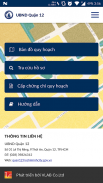
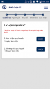
- Filing proposal provides planning certificate over the internet.
- Look status submitted dossiers.
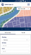
The planning information including:
- Planning subdivision
- Detailed planning
- Ranh planning sector (railways)
- Adjust local
- Information road limit
Application has information of 11 wards: An Phu Dong, Dong Hung Thuan, United thanhthanh, Tan Chanh Hiep, Tan Hung Thuan, Tan Thoi Hiep, Tan Thoi Nhat Ward, Thanh Loc, Thanh Xuan Thoi An, Trung My Tay.
Thông tin quy hoạch Quận 12 - APK Information
APK Version: 1.0.5Package: tech.vlab.ttqhq12Latest Version of Thông tin quy hoạch Quận 12
Other versions


 4.34
4.34


 4.83
4.83


Apps in the same category


